Wednesday, December 22, 2010

SANTIAGO DE CUBA, CARISOL/CORALES RESORT AND BACONAO, OCTOBER 31-NOVEMBER 7, 2010

Polish version of this blog/Wersja po polsku: http://ontario-nature-polish.blogspot.com/2010/12/in-polish-pywanie-na-kanu-w-massasauga.html

More photos: http://www.flickr.com/photos/jack_1962/sets/72157626922815626


Our third trip to Cuba in less than two years (we went to Havana in January 2009 and to Trinidad de Cuba in January, 2010) began on October 31, 2010 at the Pearson Airport in Toronto . It was windy and snowy outside and we were in an upbeat mood knowing that soon this kind of weather would become, albeit for only one week, a distant memory! Besides, just before we were about to pay for the vacation through www.tripcentral.ca , the price dropped by about $100 and we ended up paying $402 per person, everything included—what an amazing deal!

Departing Toronto-en route to Cuba

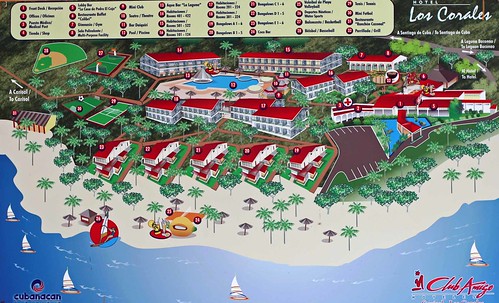
Our CanJet flight departed on time and four hours later we landed in Santiago de Cuba 's Antonio Maceo airport. It was hot and humid; as always, we went through the customs without any problems—didn't have to open luggage, nobody asked any questions. A lot of tax drivers immediately beset us, offering a ride. A small bus from the hotel was already waiting for us in front of the airport. One guy approached us, smiled broadly, shook our hands as if he had known us for ages, took our luggage and before we could even say a word, put it inside the bus; later, he came up to us with a piece of paper saying, “Tip, please”. Well... it's Cuba ! At least they don’t just stand there at traffic lights holding a cardboard sign and begging for money, like in some much wealthier countries I know :). There were about 10 of us on the bus. It was already dark, yet we could still see a lot of people along the roads, apparently waiting for buses or a ride; in Cuba hitchhiking is a way of life and government vehicle are obliged to pick up people if they can—tourist buses are exempt from such rules, although from time to time drivers do give rides to their acquaintances. The ride was OK and we made it to the hotel, the Carisol, at about 9:00 pm. We were greeted with exotic drinks and quickly checked in (the reception staff usually know English, unlike most of the other resort employees). One fellow, Julio, carried our bags to room # 502.

Carisol-Los Corales, near Santiago de Cuba

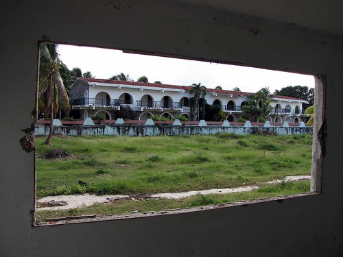
Catherine quickly discovered that the carry on bag he had delivered was not hers. After a few moments of panic she hurried off to the lobby and got things sorted out. The room reeked of dampness, it had an air conditioner, two beds, safe, TV set, fridge and telephone; since it was located at the ground level, we could sit in front of our room. The dinner was still being served, so we quickly walked back to the dining room. The food was a little dry, but overall I liked it—after all, I did not go to Cuba for its cuisine! After dinner/supper we walked to the beach; we were approached by a hotel security guard who started asking us if we had any gifts for him, like t-shirts... we pretended we didn't understand him, saying no hablamos espaniol, and quickly walked towards the beach. There were plenty of seemingly empty buildings (bungalows), probably being renovated (and such renovations may go on for years). The beach was wide, full of beach chairs, lit by lamps. Nobody else was around except for a stray dog that faithfully followed us. Eventually we got into the other hotel complex, the Corales, several hundred meters from the Carisol. It was empty—during low season usually only one hotel is open while the other one is undergoing renovations. It was a very eerie feeling—we were walking among empty bungalows, then came up to a swimming pool and entertainment area... everything was ready for tourists, yet it was so deserted! I decided to rest on one of the lounge chairs while Catherine, as always very adventurous, went exploring the other parts of the resort.

Carisol-Los Corales, near Santiago de Cuba

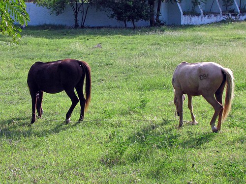
After about 20 minutes she called me to show me something: while walking along a grassy field next to the hotel, she saw something that looked like a monument of a horse head—only after a while, when this 'monument' moved, she realized it was indeed a horse! Yes, there were wild horses around the hotel and we saw them in the coming day. The horse was lying on the ground and when I approached it to take photos, it got up and trod away. Next to the grassy area there was a wall and two empty, dilapidated buildings. We saw silhouettes of two more horses wandering near those buildings. We found a path and went back to our hotel's lobby bar, but it was closing, so we had to go to another bar to have a drink. There were a bunch of tourists at the bar and we struck up a conversation with a German tourist who had been staying in the hotel for a week. He told us about his eventful trip from Europe to Cuba —because somebody on board had a heart attack, the plane dumped the fuel, turned back and landed in Paris . We chatted with him a little and then went to our room and soon fell asleep, as it had been a long day.

November 01, 2010, Monday

We must have been really tired, as we slept for a long time—we missed the breakfast and the orientation taking place in the morning. There was plenty of warm water (sometimes tourist complain about the lack of hot water), so we took a shower and were ready to start our first day of Cuban adventures. After a surprisingly tasty lunch, I set up the safe number and put some of our valuables inside it. We wandered around the resort, went to the beach and soon it was the dinner time again! I spent some time chatting with the receptionist about the latest news—that the Cuban government was going to lay off about 10% of all government employees and encourage them to set up businesses. Since almost everyone is employed by the government in Cuba , it means a lot of unemployed people!

Carisol-Los Corales, near Santiago de Cuba

Of course, setting up a business is a major undertaking: apart from the bureaucratic government regulations, it's very difficult, if not impossible, to legally acquire any supplies or inventory to run a business since the state controls everything. Thus, if the government is indeed serious about supporting private enterprise, radical changes must be implemented. Prior to heading to our room we briefly watched the entertainment, but left in mid-performance as it was not too good.

November 02, 2010, Tuesday

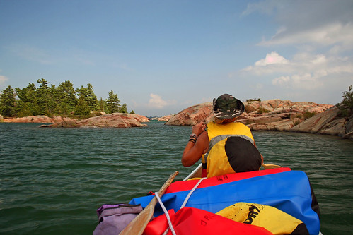
Before breakfast, we left some gifts to the maid—well, tips are very much appreciated. It's always a very good idea to leave a peso or a small gift every day; in return, you are assured to have a perfectly clean room, with very original arrangements made of towels and flower petals. After breakfast, we went to the beach. There were a couple of kayaks, free for the guests. The staff gave us life jackets, paddles and we were on the water. About 50 m from the beach there was a rocky reef, being constantly battered by the waves, as it was a little windy.

Carisol-Los Corales (Santiago de Cuba)

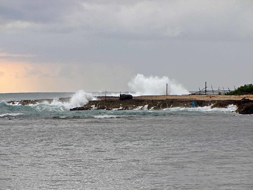
The waves were quite high—probably that was why we decided to head in that direction. Indeed, it was terrific to struggle with those waves—and at one point my kayak got overturned and I found myself in the water! It was shallow and I was wearing the life jacket, yet I had to be very careful not to be tossed against the sharp reefs. I managed to get back into the kayak, but in no time it capsized again; this time I lost my new clip-on sun glasses. Soon, I decided I had had enough and went ashore, while Catherine continued paddling, albeit close to the shore, thus avoiding the reef and the waves. While on the beach, I met two hotel employees responsible for the beach maintenance, Omar and Miguel.

Carisol-Los Corales, near Santiago de Cuba

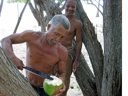
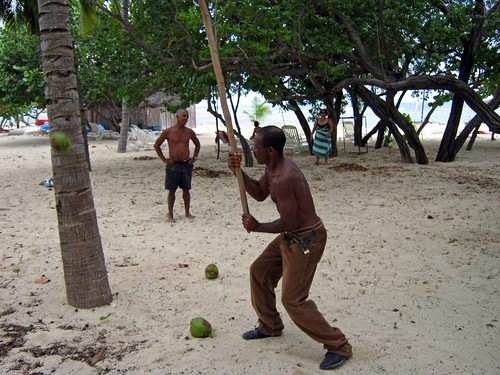
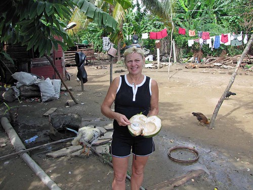
I believe they said they were both born in 1957, on the very same day, and had been friends since they were kids. Miguel gave us a couple of coconuts—he had a special long stick to get them off the tree, then masterfully peeled them with his machete and cut off the top part, allowing us to savor the coconut water and eat its tasty pulp.

Carisol-Los Corales, near Santiago de Cuba

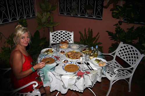
Omar said that a friend of his could take us on Saturday to the nearby village of Baconao. They were very friendly and nice guys! Later we went snorkeling—I took my disposable, waterproof camera to take underwater photos, but I was a little disappointed because I did not see much and took just three photos. We stayed on the beach till the sunset, then went to the room, had a few drinks (in order to avoid the trips to the bars, we had bought a bottle of rum and a bottle of coke in the hotel tienda, the shop) and went to the dining area for supper. A five or six person orchestra was playing various Cuban hits; I gave them 2 pesos and asked them to play “La Guarntarema”.

Carisol-Los Corales, near Santiago de Cuba

So far everything was great, the weather very good, sunny, humid and about +28C during the day. Since we were planning to go to Santiago de Cuba the next day, we talked to the receptionist—and I was so glad we did: First of all, we learned that while we were gone, this part of the resort (the Carisol, where we were staying) was closing and all the tourists were going to be transferred several hundreds of meters to the Corales, the ghost hotel we had encountered our first night.

Carisol-Los Corales (Santiago de Cuba)

Thus, we left certain instructions for the staff so that they could take our suitcases while we were gone—we wrote the note in Spanish, using our basic knowledge of this language and using the dictionary; the hotel employee was smiling a little while reading it, but the most important thing was that he understood it! Secondly, we found out that the crew bus (i.e., the bus that took hotel workers to and from Santiago de Cuba ) was leaving about 6:00 am, so we had to wake up early in the morning. After arriving at our hotel room, we packed all the stuff we were taking to Santiago to my backpack and then put all the remaining belongings to the suitcases, ready to be taken to the Los Corales by the hotel staff.

November 03, 2010, Wednesday

Of course, we were up very early; I thought it would take us just under 30 minutes to be ready... but suddenly I could not find my passport which, I could swear, I had put next to the TV set the previous night. I was looking for it everywhere; in fact, I unpacked my backpack, I unpacked my suitcase—to no avail! I thought I was going crazy—unless somebody broke into our room while we were sleeping, I could not provide a reasonable explanation for the missing passport. Finally, I started looking for it in Catherine's already packed suitcase... and lo and behold, I found it there! Well, somebody was very, very embarrassed...

Santiago de Cuba

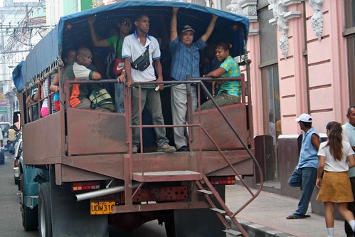
We ran to the hotel lobby, but were told the bus would be late. Indeed, we waited for an additional hour for it to arrive. There were a few tourists like us, going to Santiago. We paid 5 pesos per person to the driver and soon were on the way. The ride on the old, spartan and squeaking bus was nice, finally we were able to admire the surrounding area (because we arrived at the hotel at night, we had hardly seen anything). We saw a lot of local people along the road, waiting for buses or any other transportation. Occasionally passed by local buses, full of people—but more often such 'buses' consisted of trucks equipped with a ladder—passengers were standing up, squeezed like sardines.

Santiago de Cuba

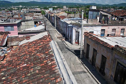
Finally, we entered Santiago. We were riding along a street with beautiful, stately mansions and some consular offices. At one point I saw a very interesting office building—with a barn-like structure on the very top—to this day I don't know what it was. We passed Plaza de la Revolucion, drove on Cespedes Avenue , passed a lot of casas particulares with the distinct blue anchor sign on the door (private houses, offering lodging options and sanctioned by the government). A lot of times we saw posters or names “26 de Julio”—since the Moncada Barracks Attack, the seminal event that gave rise to the July 26 Movement and precipitated the Revolution, occurred here in Santiago on July 26, 1956, no wonder that this city proudly displayed this significant date everywhere.

Santiago de Cuba

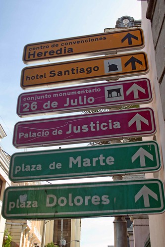
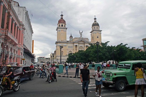
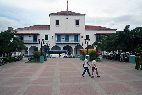
We passed a busy gas station and the even busier Bus Terminal and eventually got off the bus, along with a couple from the hotel, a Canadian woman and her Cuban boyfriend. We walked with them to Plaza de Marte, Plaza de Dolores and then to the heart of the city, Parque Cespedes. The parque was surrounded by very old, colonial buildings—Catedral de la Asuncion, Casa de Diego Velazques (built in 1516-30, the residence of the Spanish conquistador & Cuban governor Diego Velazquez, it's thought to be the oldest building in Cuba—presently housing the Museo de Ambiente Historico Cubana), Hotel Casa Granda (in Graham Green's “Our Man in Havana”, the author describes it as a hotel frequented by spies) and the Ayutamiento, the town hall—from this building's central balcony Fidel Castro made his first speech to the Cuban people on January 1, 1959, announcing the victory of the Cuban Revolution.

Santiago de Cuba

We sat on one of the benches and rested for a while; after all, we carried a backpack full of personal belongings and various gifts, as we were planning to spend two nights in this city. The first impression was that it was a very vibrant, exuberant and full of life city. A lot of people were offering us taxi rides, casas particulares or just asking for money or gifts. The traffic was brutal and I admired the brave people trying to cross the street—they had to maneuver among moving cars, trucks or motorcycles; I personally witnessed a few passers-by slightly jostled by motor vehicles—and the 'official' crosswalk made no difference to drivers!

Santiago de Cuba

What a far cry from Canada , where it's almost enough to stand at the crosswalk, or better yet, extend an arm, in order to bring all the traffic to full stop! I was really surprised that I didn't see any accidents—the streets were very narrow and one-way, often with very limited visibility and barely discernible traffic signs. Many cars or trucks were just speeding, trusting that no other vehicles or pedestrians would suddenly show up in the middle of the road.

Santiago de Cuba

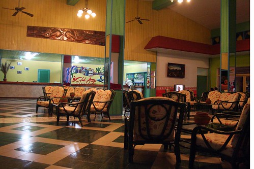
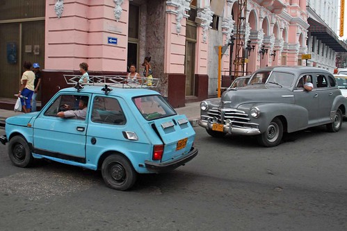
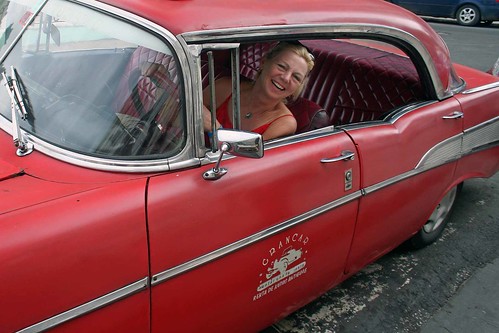
There was a row of taxi cabs in front of the cathedrals, several of them at least as old as the Cuban Revolution and we decided to hire one of them, a 1958 Ford, asking the driver to take us to Casa Maruchi [Calle Hartmann (San Félix) 357, Santiago de Cuba, Email: maruchi@infomeil.com], located several blocks away—we had read many very positive reviews about this casa and were looking forward to spending a night there! Having paid 3 pesos for the taxi ride, we met the casa's owner; unfortunately, the casa was full (as per the government regulations, only 2 rooms can be rented in any casa; since violation of this policy could result in the revocation of the casa license, legitimate casas' owner aren't usually willing to break this rule). Yet the owner took us to another casa, a hundred or so meters away on the same street. It turned out that this casa, run & owned by an English speaking physician, was excellent! [Armando Carballo Fernandez, San Felix (Hartmann) No. 306 e/ Habana (Jose Miguel Gomez) y Trinidad (General Portundo), Santiago de Cuba, telefonos 653144 y 62496 , Movil 0152466161].

Santiago de Cuba

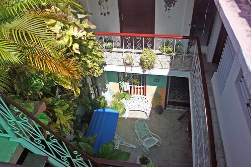
We had our own, cozy room with a bathroom and could see the street life from our windows. The building's narrow hallways and stairs led to two roof-top terraces, giving us an excellent view of the city—as well as letting us have our drinks there. I quickly took a look at his library—most of the books were in Spanish, yet I could quickly recognize familiar titles or authors (“Quo Vadis?” by Henryk Sienkiewicz)—as well as I found a few travel guides on Cuba in various languages, including one in Polish. The room was available for only one night, so we were hoping to move to the Casa Maruchi for the following night. Since we were tired, we took an hour-long power nap and were up at 1:00 pm when we ordered a dinner (to be served later) and went for a walk.

Santiago de Cuba

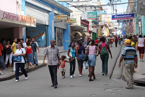
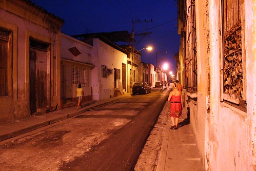
The smell of sewers and motor vehicle fuel permeated the air; the city was noisy, with many markets offering plenty of goods for the 'real' currency, i.e., the CUC, the convertible peso. We saw plenty of casas and private restaurants or cafes. Streets were full of people, some asked us for money or tried to sell us cigars (‘no fumaros’), others just wanted to talk. Several streets had old streetcar tracks, the remnants of the different era.

Santiago de Cuba

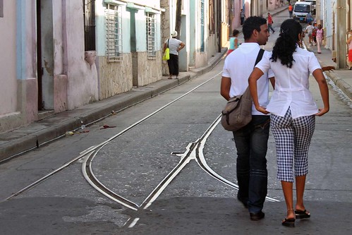
Apparently, the tram service was inaugurated in 1908 and closed in 1952. There is a very interesting webpage on the Tramways of Cuba: http://www.tramz.com/cu/sc/sc.html . I wish I could see the streetcars turning in those very narrow streets, I cannot imagine how it was possible—probably they must have been touching the corners of the buildings! In comparison to what I saw in Havana almost 2 years ago, this city was certainly much more ebullient.

Santiago de Cuba

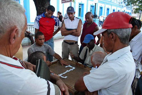
The jineteros, or the hustlers, were much more common and bothersome than those in Havana; upon seeing my backpack, they (rightly) assumed we were looking for a casa particular and were literally following us, even though we made it very clear to them we did not need their 'help'. One such jinetero at Parque Cespedes was obviously a permanent inhabitant of that area, working there every day—we ran into him several times; incidentally, his appearance was so unsavory that I'd be afraid to ever conduct any business with him.

Santiago de Cuba

Needles to say, I was taking plenty of photos, yet my Canon Rebel XT kept malfunctioning all the time; luckily, I had two other cameras with me. A couple of times I bought canned beer “Bucanero” for one peso to satiate my thirst. We walked back to our casa and spoke to the owner for a while. He was a general practitioner and had a young son, who had a rather serious problem with his leg and wore a sort of prosthesis device. He advised us to be a little careful when walking in the streets especially at night, as some people might snatch our cameras.

Santiago de Cuba

We went upstairs and on the roof top terrace had our delicious dinner, served by the owner's wife.

Santiago de Cuba

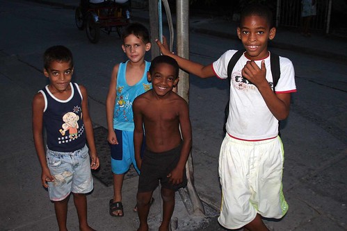
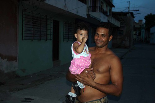
Later, when it was getting dark, we walked around the neighborhood, where I took plenty of photographs, especially of kids, and gave them a lot of gifts: we brought with us several kilograms of such items as soap, pens, crayons, note pads, stickers, calculators, key chains, manicure kits, etc.

Santiago de Cuba

Regrettably, it's a poor country and those who do not have access to the 'hard currency' (i.e., those not working in the tourist sector or not having relatives abroad) must do with what they can buy with the Moneda National, the official Cuban currency, which is not worth a lot... In fact, it's ironic that a waiter can make more money in half a day in tips than a surgeon in a month.

Santiago de Cuba

Through the open windows in our room we could hear the cacophony of noises coming from the street—people shouting, cars blowing their horns, their old and noisy engines, kids calling one another... The smell of sewers and gasoline was ubiquitous and I will always associate it with this city. Since we were very tired, it took us just a few minutes to fall asleep.

November 04, 2010, Thursday

In the morning we took a shower, packed up our belongings and paid the casa owner: the casa cost 25 CUC per night for the two of us, the two dinners 20 pesos and about 10 pesos for all the beer and water we consumed. We gave them tips as well as some gifts—and took a short jaunt to the Casa Maruchi, hoping that we could spend the second night there.

Casa Maruchi, Santiago de Cuba

However, it turned out that hurricane Tomas was just about to hit Haiti and the area of Santiago de Cuba , some flights were canceled and the tourists staying in the casa could not leave and had to stay an extra day. Indeed, the weather got a little worse. We left our backpacks in Casa Maruchi and walked to Parque Cespedes, took a lot of photos and met a black guy who had lost his arm in a motorcycle accident (or at least it was what he said). We took him to a restaurant/cafe located at one of the corner buildings near Parque Cespedes and bought him a Mojito; he appeared to just want to talk with us.

Santiago de Cuba

While Catherine enjoyed chatting with him, I went to the adjacent building across the street, the City Hall with the famous balcony where Fidel Castro had made his historic speech. I asked if it was possible to get onto the balcony, but even the incentive in the form of a 5 peso tip didn't open the door, so to say. We bought several postcards in a store located at the bottom of the cathedral, near the tax stand. One nice midget lady very insistently begged us for money; eventually I gave in, but took a few photos of her in return.

Santiago de Cuba

Then we went to the Hotel Casa Granda, where we had some beer on its terrace overlooking Parque Cespedes, where we could enjoy watching the city life below. Before we left for Cuba, Catherine had purchased a big bag containing individually wrapped chewing gums, sold for the Halloween—it was an excellent idea, she was giving it away and everyone loved the gum—she was even throwing it from the hotel terrace to some people who were asking us for candies. I wrote several postcards to Canada and Europe and mailed them from the hotel, but only about half of them ever arrived to their intended recipients. The Museo de Ambiente Historico Cubano was our next destination—it had plenty of very old and interesting furniture from various colonial periods—as well as we could admire the Casa de Diego Velazquez and its Moorish style.

Santiago de Cuba

On our way back to Casa Maruchi we stopped at the very well-known Casa de la Trova, famous for its music performances, but they only started at 8:00 pm.

Santiago de Cuba-Casa de la Trova

Once at the casa, we spent there an hour or so sitting on the roof top terrace talking to the casa owner's husband and admiring the city. The weather was changing—the hurricane must have moved over Santiago; black clouds formed, it started raining and we moved down to the 'living room', which was full of green plants, had an impressive sculpture/fountain and even a live turtle!

View from the Casa Maruchi, Santiago de Cuba

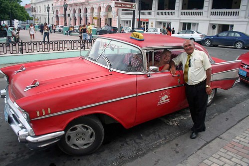
The owner (Ms. Maruchi) called the cab for us, the same Ford in which we had arrived the day before. She also asked if one of her Cuban guests could, ummm, "share" the cab with us. It was an old, classic American car, the 1958 Ford. Perhaps it was a little slow; the engine stalled twice in the middle of nowhere as we drove through the torrents of rain and flooded highway, but the driver managed to get it working and delivered us safely to the hotel in less than 2 hours.

Santiago de Cuba

He also increased the price but we decided it was worth it. Little did we know at that time, but as a precaution, the airport in Santiago de Cuba was shutting down due to the hurricane and the last plane to depart before the shutdown was a Cuban flight from Haiti, via Santiago, to Havana (Aero Caribbean Flight 883): tragically, it crashed en route to Havana, killing everyone on board (61 passengers and 7 crew). We went to the Corales resort—the Carisol was now temporarily closed. At the reception we found out that our luggage had been taken to the Corales and now we were in room number 516.

Carisol-Los Corales, near Santiago de Cuba

We took a shower and went for supper. It was raining and windy, the hurricane passed over Haiti and we only experienced its peripheral limits. After supper we went to our room—it was nicer than the other one and the smell was gone, as well as we could see the entertainment from our balcony. We watched the news and found out about the plane crash in Cuba as well as there was another potential plane crash, this time with the Quantas, Australian Airlines, whose plane lost on of its engines.

November 05, 2010, Friday

Tired, we slept till 11 am, skipping breakfast and went straight to have lunch. A few words about the food: it was a buffet-style, all-you-can-eat and overall it was quite good; besides, we always enjoyed a few glasses of red wine or beer with our meals. I never had any problems with picking something delicious—especially enjoyed chicken, pork and omelets in the morning.

Carisol-Los Corales, near Santiago de Cuba

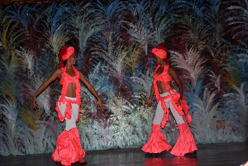
Not that the food in Havana (at the Tropicoco Hotel) and Trinidad de Cuba (Hotel Costasur) was bad, but it was certainly different and probably this resort offered the best food (some tourists always complain about food—Cuba is not known for great cuisine, but from my experience, it was always possible to have good and even tasty food—and I never experienced upset stomach or similar symptoms). Another positive thing was that the resort staff did not really ask for or seem to expect tips—we did not feel the pressure that we had to give them tips—nor did they offer us any unsolicited 'gifts', anticipating money in return, as was the case in the Costasur. We had a few musicians play Cuban music (one was a blind singer) and usually people were giving them a peso or two, but again, there was no feeling of compulsion to do so. Only once a magician, after showing us a few tricks, was going from table to table, demonstrating a box trick and then trying to sell the box for 5 pesos.

Carisol-Los Corales (Santiago de Cuba)

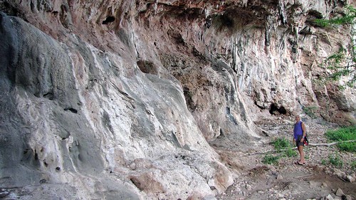
Later that day we walked along the road leading from the hotel to the village of Baconao and explored interesting caves and similar geological formations. While walking on the hotel beach, we met a security guard (with a .38 caliber pistol—which he said he had never had to use) who pointed to a few very crabs. It was raining, so we took shelter in an unused bar; having procured a bottle of rum and coke beforehand, we were able to enjoy a few drinks!

Carisol-Los Corales (Santiago de Cuba)

Once the rain was over, we walked on the beach again and I observed and took photographs of some kind of a lizard on the tree. After supper, we again walked around the beach, saw some crabs and then went around the abandoned buildings (they were very close to our hotel).

Carisol-Los Corales, near Santiago de Cuba

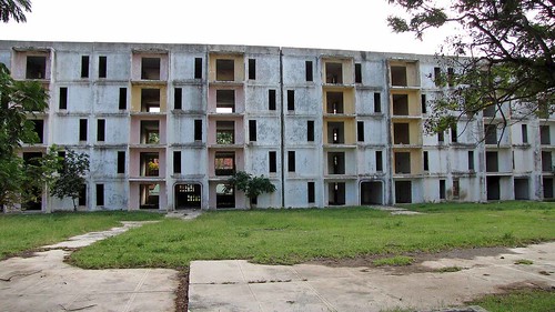
A security guard explained to us that there was a school for workers and they used to live in those buildings. While wandering around the hotel property, we spotted a few horses.

The entertainment was on tonight at about 9:30 pm, so we went back to the stage area and met the German tourist we had seen when we arrived to this resort. He was supposed to depart tonight, but due to the storm, his flight was canceled and he was enjoying his extended vacation.
Once the entertainment was over, we walked on the beach and around the abandoned buildings. There was one more thing we wanted to do—namely, visit the village of Baconao, which was located several kilometers from the hotel. Omar and Miguel, the 'beach guys', said that their cousin can drive us there, but when we were looking for them earlier today, we could not find them. So, we were planning to simply hire a horse-drawn buggy in the morning in front of the hotel. Coincidentally, while heading to our room, we encountered a guy who started talking to us and said that he could arrange such a carriage for us tomorrow morning for 3 pesos per person; we promised to show up in front of the hotel at 10:00 am, right after breakfast.

November 06, 2010, Saturday

There were a few buggies in front of the hotel and we immediately recognized the guy we had spoken with yesterday; the one-horse buggy was driven by another fellow who tried to sell us a watch on the beach a few days before.

Baconao near Carisol-Los Corales (Santiago de Cuba)

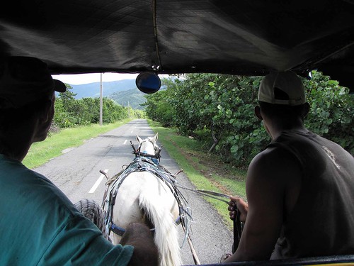
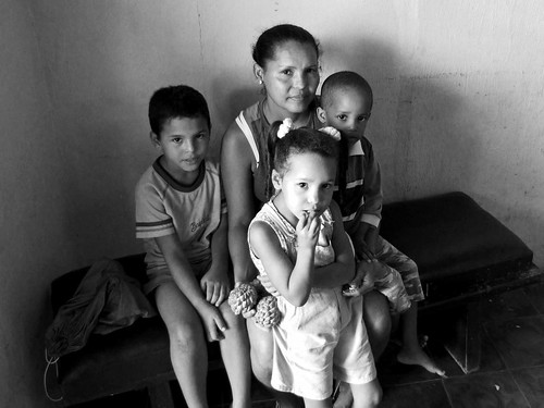
The ride was nice, we passed the caves we had visited the other days, two restaurants and about 45 minutes later reached the center of the village of Baconao. It was a rather poor village. There was a beauty parlor in that 'central square' which we visited. I took plenty of photographs of a mother with children as well as of workers and customers, rewarding them with some gifts (they wrote down their addresses and a few months later I mailed them the photos).

Baconao near Carisol-Los Corales (Santiago de Cuba)

We also went to a nearby government store; it had some rudimentary supplies, cigarettes, and simple toys; apparently ration cards, in addition to pesos, were required to make purchases.

Baconao near Carisol-Los Corales (Santiago de Cuba)

We wandered around the village and were invited by a family to their simple rural home. I took photos of them, they grabbed a few coconuts, split them open and gave them to us—we enjoyed the coconut water and its very filling pulp.

Baconao near Carisol-Los Corales (Santiago de Cuba)

We left them gifts (later I mailed them the photos) and went on, exploring the village, meeting other people, taking photos. After reaching a road with a uniformed sentry, we had to turn back.

Baconao near Carisol-Los Corales (Santiago de Cuba)

We were told the road led to Guantanamo where the American base was located (although it was about 40 km. away). In fact, it was supposedly possible to see from our hotel beach American ships going to the Guantanamo base; we did see some ships very far from the shore, but obviously could not determine their flag. Altogether we stayed in the village for over one hour and all this time the buggy was waiting for us.

Laguna de Baconao

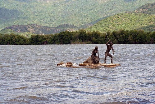
On our way back to the hotel we stopped at Laguna Baconao—a lake (?) which had an original bronze sculpture in the water of two Taino fishermen (the Taino people became extinct in the 16th century) and visited a crocodile farm nearby. There was a boat for tourists on the lake, but since it was very windy, we could not use it. At the restaurant we ordered beer (for us and the buggy drivers) and returned to the hotel, at which time we paid him and gave him and his friend some gifts.

Carisol-Los Corales, near Santiago de Cuba

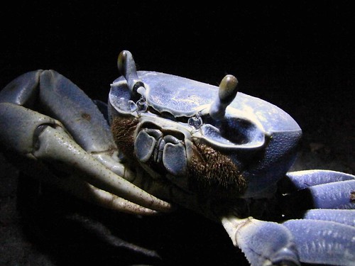
After supper we wandered around the hotel and on the beach, spotting a few colorful crabs; at that time my video camera developed a mechanical problem—funny, but it was my the third camera that failed in Cuba!

November 07, 2010, Sunday

We were up at 8:30 am, but decided to skip breakfast and go directly to the beach, to enjoy our last day in Cuba. Unlike yesterday, it was sunny and calm—the hurricane Tomas had passed, but not before doing some damage and leaving a number of fatalities in Haiti, already devastated by the recent earthquake (coincidentally, the earthquake occurred while we were in Trinidad de Cuba).

Carisol-Los Corales, near Santiago de Cuba

Two hours later we went back to our room, packed up quickly left the room—we were supposed to leave the room before the noon so that the cleaning staff could prepare it for arriving tourists. We left the luggage in the lobby and proceeded for dinner—as always, it was quite good and tasty, we had plenty of wine, talked to some tourists and then went for our last walk around the hotel. We passed a restaurant located outside the hotel and entered the abandoned building adjoining to the hotel.

Carisol-Los Corales, near Santiago de Cuba

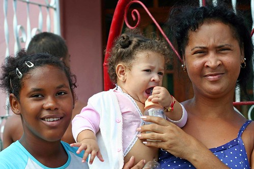
They were totally empty, nothing of value was left. I took a few photographs. We met the two guys who had taken us to Baconao the other day. There were some goats, cows and horses around the buildings; as we were walking back to the hotel, I spotted a woman with kids near the restaurant. I took plenty of photos of this group and gave them the remaining gifts.

Carisol-Los Corales, near Santiago de Cuba

At that time a totally drunk guy, who could hardly walk, was trying to mount a horse with his friends' help; once he was in the saddle, he, or shall i say the horse, rode off—hopefully the horse knew the way!

Carisol-Los Corales, near Santiago de Cuba

We ordered a few cappuccinos in the hotel lobby and got on the bus that was waiting for us to take us to the airport in Santiago de Cuba. The journey to the airport gave us an opportunity to admire the countryside and the surrounding Sierra Mountains. It was in those mountains that Fidel Castro and his men were hiding and fighting after the Moncada Barrack attack; I can only imagine how difficult it was for the Batista regime to fight them in such rugged terrain. In fact along the road we saw quite a few less or more elaborate monuments, presumably commemorating revolutionaries who were killed there or places where battles or skirmishes with the Batista army took place.

Once we got to the airport—the same airport from which that doomed flight had taken off for its final journey just three days earlier—we waited for the plane, talked a little to our fellow travelers and eventually saw our plane land, delivering a new group of tourists from Toronto. This time we flew to Cayo Largo, picking up tourists who had been on our plane from Toronto and then flew to Canada—this destination added at least two extra hours to our flight. Thus, the trip back home was quite long and tiring, but we eventually landed after 1:00 am in Toronto.

Baconao near Carisol-Los Corales (Santiago de Cuba)

We genuinely liked our holiday—we visited two casas particulares and two hotels, the hotel atmosphere was very nice, we enjoyed plenty of time on the beach (not that I am particularly interested in the beach anyway), food was very good, staff very nice—I would certainly recommend the Los Carisol/Corales resort! Our excursions to Santiago de Cuba as well to the village of Baconao were certainly the highlight of our trip, as they added a lot of variety to the otherwise somewhat prosaic stay in the resort (unless one likes spending all the time on the beach and in/around the hotel). I look forward to visiting Cuba again; considering the recent relaxation of the government restrictions on small business and forthcoming plans to issue hundreds of thousand of permits to people so that they could carry out private business activity, I am sure that no matter what, Cuba will be changing—for the better.

Polish version of this blog/Wersja po polsku: http://ontario-nature-polish.blogspot.com/2010/12/in-polish-pywanie-na-kanu-w-massasauga.html

More photos: http://www.flickr.com/photos/jack_1962/sets/72157626922815626

Tuesday, August 31, 2010

Canoeing around Philip Edward Island, Ontario, August 11-20, 2010

Wersja w języku polskim/The Polish Version of this blog entry is here: http://ontario-nature-polish.blogspot.com/2010/08/in-polish-dziewiec-dni-na-kanu-dookoa.html

[Philip Edward Island] is a paddler’s paradise(...) the opportunities for canoeing and kayaking here are exceptional.—Kas Stone, photographer, hiker, canoeist and author.

[Circumnavigating Philip Edward Island] is a fantastic 5-to-7 days route that has been rated by a number of leading canoe and kayak magazines and websites as one of the top ten paddle destinations in North America.—Kevin Callan, author of many books on canoeing in Ontario.

When you travel along the north shore of Georgian Bay, you are travelling in the footsteps of history.—Jonathon Reynolds i Heather Smith, „Kayaking Georgian Bay.”

Prehistoric... frozen in time... ancient, silent, mountains rising from the deep green-blue water; islands worn smooth by hundreds of thousands of years of waves licking at their shores (...) These are the things that come to mind when trying to describe the heavy atmosphere of the Bay’s northern shore.—Russell Floren and Andrea Gutsche, “Ghosts of the Bay”.


Departing Toronto—August 11, 2010

We had been planning this trip since December, 2009—it was during a presentation by Kas Stone, a freelance writer and photographer, when she mentioned Philip Edward Island—and once we realized that this was one of the 10 best canoeing trips in North America and did not require any portaging, we were, so to say, sold!

With Kas Stone--December 15, 2009

We had done some online research on this trip, read books by Kas Stone (“Paddling and Hiking the Georgian Bay Coast”), Kevin Callan (“A Paddler’s Guide to Killarney and the French River”) and Jonathon Reynolds and Heather Smith (“Kayaking Georgian Bay”) and the more we were finding out about this area, the more our excitement and anticipation grew! We had had paddled in that area many times (French River, Pickerel River, the Massasauga, Killarney), yet paddling around Philip Edward Island certainly was something different, something more challenging and exciting.

Canoeing around Philip Edward Island, Ontario

Philip Edward Island, located in the northern part of Georgian Bay, just south of Killarney Park, is about 19 km x 5 km, and is not part of any park—miraculously, it is still crown land, so no reservations or fees were required and we could camp anywhere we pleased. The island itself is a geological gem—formed by about 1.6 billion years ago, then more recently (i.e., between 4 million and 12 thousand years ago) covered many times with sheets of ice, which scoured away soil and rocks; also, glacial melting carved incredible shapes in the bedrock. That is why the southern part of the island is composed of hundreds or even thousands of small islands, rocks, bays, inlets, coves which only enhance the canoeing experience.

Henry Wolsey Bayfield, the British surveyor and later admiral, surveyed Lake Huron after the war of 1812 and named the island and the inlet after his assistant, Philip Edward Collins. He also named hundreds of other places—since the area abounded with islands, he soon ran out of the more distinguished names and started naming them after his friends, the crew and even the crew’s relatives and friends.

Driving from Toronto to Killarney, Ontario

So, eight months have passed since that presentation... and here we were, ready to embark on our journey! After one hour of packing, we left Toronto before noon and in no time were cruising on Highway 400 up North. About 2 hours before arriving in Killarney Park, we stopped at Grundy Lake Post, where we stored our newly-bought canoe, a Kevlar “Adventurer”, and put it on the roof of the car. It was to be the second trip we were embarking on with this canoe, yet we were confident it would be up to the challenge. We passed the Pickerel River (where we had paddled less than one month ago), the French River (we had paddled there many times over the past 2 years) and less than an hour later we turned left into road no. 637, leading to the Town of Killarney—as well as Killarney Provincial Park. We saw several cars, most of them carrying kayaks or canoes on their roofs, as well we spotted a titian fox on the side of the road—alive, that is! Eventually we reached the main gate of Killarney Provincial Park.

Arrival: Killarney Park Entrance

As expected, we were greeted by a large sign, “Campground Full”. Fortunately—and luckily—we had managed to reserve the only available site # 36 just days before. The site turned out to be quite nice, close to the showers and main building. Not that we cared that much—after all, we were only staying there for one night. I set up the tent and started a campfire as it was getting dark. Our dinner consisted of excellent salmon (alas, I did not catch it—it was Catherine who bought it in Toronto). A warden came to our campsite to advise us about keeping our food hidden in the car because there were plenty of raccoons in the park. Since we mentioned we were going to circumnavigate Philip Edward Island, we spend some time chatting with him about this trip—of course, he had done it several times. Perhaps 30 minutes after he left, several raccoons came to our campsite. Totally not intimidated by our presence, they sniffed at our gear and quickly overturned the barrel (where we kept our food); not being able to open it, they moved on—after all, there were well over one thousand other campers in the park! We hit the sack after midnight.

Day One—August 12, 2010

Day One (Purple)

We had coffee and oatmeal for breakfast—and all of our breakfasts over the next 9 days were like that—simple, quick and very healthy. Once we packed up the tent, we drove to the park building to purchase a parking permit to park our car at the access point at Chikanishing Creek. Even though Philip Edward Island is still crown land, the parking lot is in the park. The price was exorbitant--$14 per day! It was a lot, almost as much as one can expect to pay for parking in downtown Toronto! Well, it seems the Ontario government decided to take advantage of its relative monopoly for the access to Georgian Bay and like private businesses, wants to make money. So, for 9 days of parking costs $126 (yet it is possible to buy an annual pass for just over $100).

After leaving the park, we drove south towards the town of Killarney and after several kilometers turned left into a narrow road and in no time reached the Chikanishing Creek Access Point (called “the Chick”).

'

The parking lot was full of cars—and the whole place was buzzing with activity. The Chikanishing trailhead is located at this point, so lots of hikers were milling about. Some kayakers and canoeists were just coming in after splendid days on the water, others were just unloading their cars and putting canoes/kayaks on the water. There were also a number of kayaks and canoes stored near the boat ramp, probably dropped off by rental companies and amazingly left unlocked. We managed to drive to the ramp, launched the canoe, unpacked our stuff and quickly parked the car so that others could use the ramp. After 30 minutes our canoe was neatly packed. The quantity of our gear caught attention of some people, especially kayakers, who cannot take a third of what we had. I explained that we just wanted to show how NOT to pack a canoe! Well, I have to admit—I am not a light packer (and neither is Catherine). We want to travel in relative comfort thus we bring chairs, extra tarps, kitchen equipment, extra propane, extra safety equipment and of course, I always carry my cameras, tripods and fishing tackle.

Day One: Departure from the Chick

At 13:13 (i.e., 1:13 pm) we departed from the Chick and paddled on the Chikanishing Creek, passing a few kayaks, motor boats and canoes. We were surprised at the number of motor boat; actually surprised that they were allowed at the access point at all. A couple of minutes later majestic and imposing rocks came into view—and we entered the open waters of Georgian Bay! The area was stunning—there were a lot of islands with characteristic wind-swept pines, formed by western winds. Since prevailing winds are from the west, it is best to paddle around the island counterclockwise—that way the winds should ‘push’ you whilst you paddle on the exposed southern shoreline. On the left we passed South Point and now were paddling south of Philip Edward Island.

Day One: Canoeing

The weather was perfect—it was warm, sunny and the light easterly wind made it possible for us to paddle more on the open water. It was such an amazing feeling when we were paddling south and did not see the opposite shore—we felt as if we were paddling on the sea or ocean! And the clear azure colour made us almost want to double-check for saltwater. When we looked towards Killarney Park, we saw the distinctive ranges of ‘white mountains’ (La Cloche Mountains, mainly composed of quartzite, are one of the oldest mountain ranges on earth); I am sure one could be fooled into thinking it was snow!

Day One: Canoeing

The scenery was breathtaking; we maneuvered among the myriads of the barren islands, shoals and rocks, often had to paddle around rocks submerged just under the water. But let me diverge a little and go back 171 years in time...

In 1836 Anna Brownell Jameson (1794-1860), a British writer, arrived in Canada (Upper Canada) to join her husband who was soon to become the first Vice Chancellor of the Court of Equity in the province. She spent the next year travelling to such places as Niagara, Hamilton, Woodstock, London, the Talbot Country, Detroit, Mackinaw Island; she also traveled, mainly in a canoe, from Sault Ste. Marie to Toronto, visiting such places as Manitoulin Island and the site of town of Killarney, as well as along the shores of Georgian Bay, just south of Philip Edward Island and near the mouth of the French River. During her extensive travels she was thrown “into scenes and regions hitherto undescribed by any traveler and into relations with the Indian tribes such as few European women of refined and civilized habits have ever risked and none have recorder”. The result was her book titled “Winter Studies and Summer Rambles in Canada”, published after her return to England. This book gives a very vivid picture of the area, people and customs of the time.

While travelling south of Philip Edward Island towards the south, Anna Jameson also appreciated the beauty of the area:

“This day we had a most delightful run among hundreds of islands; sometimes darting through narrow rocky channels, so narrow that I could not see the water on either side of the canoe; and then emerging, we glided through vast fields of white water-lilies; it was perpetual variety, perpetual beauty, perpetual delight and enchantment, from hour to hour. The men sang their gay French songs, the other canoe joining in the chorus”.And later, she writes:
“We landed at sunset on a flat ledge of rock, free from bushes, which we avoided as much as possible for fear of mosquitoes and rattle-snakes; and while the men pitched the marquees and cooked supper, I walked and mused. I wish I could give you the least idea of the beauty of this evening; but while I try to put in words what was before me, the sense of its ineffable loveliness overpowers me now, even as it did then. (...) The lake lay weltering under the western sky like a bath of molten gold; the rocky islands which studded its surface were of a dense purple, except where their edges seemed fringed with fire. They assumed to the visionary eye, strange forms; some were like great horned beetles, some like turtles, some like crocodiles, and some like sleeping whales and winged fishes; the foliage upon them resembled dorsal fins, and sometimes tufts of feathers. Then, as the purple shadows came darkening from the east, the young crescent moon showed herself, flinging a paly splendor over the water. I remember standing on the shore, ‘my spirits as in a dream were all bound up’—overcome by such an intense feeling of the beautiful—such a deep adoration for the power that had created it.”Even though those words were written 171 years ago, the splendor and beauty of the area, as well as the emotions they stir have not changed.

In the south we saw several islands—the Foxes, which offer awesome scenery. They are very popular with especially with kayakers because reaching them requires paddling on the open waters of Georgian Bay for 2-3 km. Since the weather on Georgian Bay can be unpredictable, it may be sometimes difficult to get to them—or end up being stranded on them for several days, waiting for the weather to improve and the winds to subside. Initially, we were considering paddling to the Foxes as part of our trip; since the weather was ideal, it would be very easy to get there.

Day One: Canoeing

However, we decided not to go there at this time, but leave the Foxes as the destination for our next trip (yeah, we already made a decision to go there again!). We continued paddling east, enjoying the surroundings. We explored Winakaching Bay, later paddled more towards the south, on more open waters of Georgian Bay, even reaching East Fox Island, which is part of the northern part of the Foxes.

Day One: Canoeing

We paddled around Blockbuster Island—one big hilly rock, offering excellent viewpoints—and then paddled to West Desjardin Bay. It was dotted with islands, shoals and startling rock formations.

Day One: Canoeing

I have to add that I always carried my Garmin GPS unit with me—yet sometimes I did not exactly know where I was, because the topographical map only showed bigger islands—and due to the relatively low water level, the number of visible islands and rocks had greatly increased! I cannot imagine canoeing without GPS—navigation using the compass would be very tiresome and time consuming (although in case of this trip, we knew that we had to simply paddle east... and then north... and west—yet it was great to know where we were). I know that some purists do not use GPS, but I am certainly not one of them—it is my philosophy that by using GPS I have more time to relish the surrounding scenery and I do not have to constantly worry if I am lost.

We passed Pig Island, paddled for a while among reddish rocks and on the west side of West Desjardin Bay we spotted an excellent campsite—it had a fire pit and was easily accessible. We decided to spend the first night here.

Our Fist Campsite, Day One

We unpacked our gear and I quickly set up the tent on a flat rock. The fire pit was located several meters up on a small hill, which also made a great viewpoint: we could see whole West Desjardin Bay and unfathomable waters of Georgian Bay. There were also a lot of scenic hills and rocks on the shore. Beside the tent there were five steel rings driven into the rock; probably over 100 years old, they were once used to hold the booms of logs or perhaps docking boats. Well, this seemingly isolated place was full of history! I do not even want to mention how many photos I took—luckily, my partner was very understanding and always willing to accommodate my mini photo session by stopping or paddling solo while I was ‘playing’ with my cameras or camcorder. Not long ago she bought a camera and often took photos as well. We had no problems finding firewood—some islands are barren and firewood must be brought there or scavenged along the way. Just in case, we did carry a little wood, enough for one campfire.

View From Our First Campsite

Around 9:00 pm, when it was getting dark, we got into the canoe and paddled around our campsite, often dodging rocks and maneuvering through narrow rocky channels and shoals. Paddling after sunset is very enjoyable, especially when the moon is full—there are no mosquitoes on the water, it is not very hot, humidity level decreases. It is a good idea to leave a candle or flashing flashlight on the shore—a few times we almost got lost while paddling at night—all those islands and rocks are so similar that it is easy to get lost during the day, let alone at night! At about 10:00 pm we unpacked our marinaded steaks, garlic and red sweet potatoes, got one bottle of red wine and hung the barrels containing our food on a tree. It was not very easy, but of course, one should do it every night due to bear activity. However, it is often very difficult, if not outright impossible, to find a suitable tree, with a strong branch (some appear to be strong, yet they quickly break) and the whole ‘hanging process’ takes a lot of time and effort. In general, bears try to avoid people and very few campers have had problems with bears—nevertheless, I had had bears visiting my campsite on three separate occasions. I also had a Bear Spray, which I always had handy; supposedly if used properly, it is 100% effective—but I would not like to ever test it!

After a few minutes we had the campfire going and one hour later we were having our dinner; considering that our lunch consisted of a Vegan Protein Shake, we were always glad to have dinner! Before going to bed I listened to the weather report (I brought with me a Marine Radio, a Ham Radio with weather channels and two small FSR radios with weather channels—as well as a regular AM/FM radio)—the forecast called for winds of 10 knots per hour, so we hoped the weather would be fine the next day. After 1:00 am we were sound asleep.

Day Two, August 14, 2010

Day Two (Blue)


Because it was the first day of our trip when we did not have to rush anywhere, we awoke at... 3:00 pm! Apparently we needed the rest; besides, the fresh air had a very soporific effect on us. The weather was great—sunny, warm, yet there was some wind. Although it was somehow late, we packed up and were on the water before five o’clock, ready to paddle on. Ignoring the wind and waves, we proceeded south of PEI, paddling on the exposed waters of Georgian Bay. Our fully loaded canoe had no problem with going against the waves. The scenery was stunning—we always saw new rock formations, some totally barren. We passed a few kayakers.

Day Two: The Mink

On one of such rocky a furry animal appeared, probably a marten; ignoring our presence, it went about vigorously eating a crayfish. Because the wind was increasing, instead of paddling around Silver Island from the south, we took the Silver Island Channel, which sheltered us from the wind. The we paddled to the south, towards the open water of Georgian Bay, on Big Rock Bay.

Day Two: Canoeing

The only optional portage of this trip was located there and in case of strong winds, it would save us rounding Big Rock Point. Even though the waves were quite big, we never considered using the portage. On the left we saw some tents and kayaks; some people were standing on shore and staring at us. It quickly became apparent why: the more we proceeded towards the south, the windier and wavier it became. In addition, there were some submerged rocks, now exposed and whipped by the waves. As we already reached the point of no return as we paddled as strongly as possible. There were two big rocks—and plenty of whitecaps all over them; we had to paddle exactly between them. We had a very tough time making it through the gap, the canoe was often pushed towards the rocks and it took a lot of incessant paddling to steer it away from the rocks. Nevertheless, the canoe was quite stable and we were moving forwards; all this time we made sure it is positioned at 45-90 degrees towards the waves. Finally, we were between Big Rock Point and Red Crow Island and slowly started turning north. We had to continually watch for the waves which were often pushing us towards semi-submerged rocks; if we hit such rocks, it could have resulted in a serious damage to our canoe. On the other side of the Point we saw a tent and another group of people looking at us. Yet we made it! The more we paddled towards the north, the calmer it became. A couple of minutes later we were paddling on the still water—only the roars of waves hitting the rocks and whitecaps reminded us that the wind is still blowing!
Day Two: The Second Campsite

We paddled among very scenic rocks, inlets, shoals and narrow gaps and finally reached a nice camping site on an island, located just vis-à-vis the other end of the Big Rock Portage on the opposite shore. As always, we set up the tent on a flat rock and I built a small fire pit next to the steep rocky wall (when the water level is normal, most of the campsite is under the water).

Day Two: The Second Campsite

Once we started the fire, we could analyze the day’s events. We realized we were quite lucky that we made it around Big Rock Point—after all, the portage was there for a good reason! In fact, Kevin Callan mentions in his book that this portage had been used for the past several hundred years by Native People and traders. We sat around the fire till very late, totally sheltered from the raging wind, which made a howling sound from afar. We did not hang the barrels—we could not really find any appropriate trees nearby—besides, it would have taken us a lot of time and effort.

The Big Dipper

So, we placed a few rocks on the cover so that we could hear if any animal were to overturn the barrel. We did not hang the barrels on our subsequent campsites either, mainly because of the lack of good trees—yet no animal (nor human) ever tried to get into the barrels.

Day Three, August 14, 2010

PEI Day 3 (Green)

We were up just before noon as a group of kayakers was passing by—probably they were looking for the portage, but left after a couple of minutes. It was still windy, cloudy, even a little rainy. After breakfast we paddled towards Georgian Bay. Once we left the sheltered bays, the canoe started to go up and down on the waves; some of the waves were forming whitecaps. Catherine started to feel a little seasick.

Day Three: Canoeing

We reached a group of rocks, which were being hit by waves which washed over them, producing spray—we had to continue paddling all the time to avoid being thrown into the rocks. I managed to get my cameras out and take several photos, but was ready to grip the paddle in case of problems. We stopped near the rock on which the kayakers camped yesterday and for almost one hour relished the awesome view—the boundless waters of Georgian Bay, the scattered islands and rocks in the bay and the unrelenting waves that kept hitting them.
Day Three: View from Big Rock Point

Two kayakers appeared among those islands; we waved to them—they never ventured on the open waters, but stayed in the sheltered area. On our way back we visited a small bay, located just a hundred meters from our campsite. A (home made?) house boat was docked there, tied with ropes to the shore.

Floating Home

Perhaps the owner avoided property tax this way! Then we paddled by our campsite and towards Garbage Bay. It was quite charming, dotted with rocks... and suddenly, there was a pile of garbage or rather bygones from another decade on its shore! At least its name DID live up to its reputation! Half an hour later we paddled back to the campsite; finally, I could read some old newspapers, spent some time fishing (but it was too shallow and did not catch anything), listened to the radio and weather forecast.

Day Three: Our Third Campsite

We started the campfire at about 9:00 pm, had our traditional meal (still had marinaded steaks) and went to bed after one in the morning.

Day Four, August 15, 2010

Day 4 (Red)

I was up at 7:00 am—and I was so lucky, as it was very foggy! I grabbed all my cameras and camcorder and began taking photos and videos—and then went back to the tent, only to wake up again at noon. Catherine had suggested we romantically paddle in the mist, but there were lighting flashes around.
Day Fourth: Second Campsite

We swam a little, then had breakfast, packed up and exactly at 14:14:14 (i.e., 1:14:14 pm.) left the campsite. The forecast was not very promising—“Strong winds, up to 24 knots per hour”. For that reason we decided to keep as close to the shore as possible and take all the available channels—which, according to the map, should shelter us from the wind. Once we passed Garbage Bay, we hoped to take the channel between Bateman Island and PEI—yet the channel appeared to be very overgrown and shallow.

Day Fourth: Canoeing

We got out of the canoe—Catherine was pulling the canoe, I was pushing it—but to no avail, because gradually the water totally disappeared and like it or not, we had to go back. The water level had gone down in the past years and thus some channels were not navigable, even for canoes. So, we paddled around Bateman Island—it turned out to be a very charming area and the many bays and islets sheltered us from the wind. There were a number of cottages and buildings on the south side of Bateman Island and on some adjacent islands—some of them were quite big and appeared to be part of some old community. We asked a couple sitting on the dock and they confirmed that they were indeed part of an old commercial center. Once we paddled around Bateman Island, we proceeded towards Cross Bay—the waves again became bigger and we had problems controlling our canoe; a motor boat with several people was passing by and everybody was looking at us as we were struggling with the waves—because we were paddling close to the shore, the waves, bouncing off the rocks, became augmented and the water became very turbulent. Sometimes the canoe positioned itself parallel to the waves, causing a hazardous ‘rocking effect’—both of us had to keep paddling very hard to right the canoe.

Day Fourth: Canoeing


After a while we entered rocky ‘canyons’, sheltered from the wind and waves—it was one of the most enjoyable part of our journey! Finally we reached Bear Bay, took a short channel to Moose Bay and we were planning to take yet another channel to Deer Island Bay—but the latter turned out to be very overgrown with water grass. We did not know if we could make it and feared that we would have to paddle around the south side of Deer Island.

Day Fourth: Canoeing

Despite the dense rushes there was enough water for the canoe to move, albeit very slowly and we made it to Deer Island Bay—while traversing this route, we caught plenty of spiders and other bugs which fell into our canoe. Deer Island Bay was the last bigger bay before Beaverstone Bay. According to the map, we were supposed to paddle south, then turn east—and either paddle through a passage between Hincks Island and PEI or between Hincks Island and Toad Island—yet the latter route was very exposed and windy. Upon entering Deer Island Bay, we immediately felt the power of the wind and waves; the farther south we paddled, the windier and wavier it got.

Day Fourth: View From Our Third Campsite

Our objective was to reach Hincks Island and camp there overnight; even though we saw the island on our left (several tents were already set up there), it was very difficult for us to reach it due to high waves—if we had turned left, we would have been paddling parallel to the waves, which was not advisable. So, we slowly paddled against the wind and waves and when we were far enough, we suddenly turned the canoe 180 degrees and paddled north. Tired, we were trying to find the passage between PEI and Hincks Island—it turned out that the passage was there, yet a narrow sandbar blocked us from entering it.

Day Fourth: Third Campsite (the Sandbar)

We paddled to that sandbar and decided to make our camp there. In spite of the strong wind, we set up our tent on the top of the nearby rocky hill, moved all our equipment behind the rock and then pushed our canoe over the sandbar and docked it in the passage, where it was sheltered from the wind.

Day Fourth: Third Campsite

Several hours later we wanted to check out if the passage is navigable and set out on a short canoe jaunt. The passage, although shallow, was perfectly navigable, as long as we watched for the submerged rocks, and quickly entered the big bay on the other side of the passage. The wind increased and after just a minute of paddling we realized that the waves had become much bigger in the past three hours. Nevertheless, we did not feel we were in any danger and even enjoyed this whole experience. Slowly, we paddled to the first rocks, which were incessantly hit by the waves, causing a lot of spray. I got out my camcorder and started videotaping... and then I spotted a wave in front of our canoe which was 2 times bigger than the others... Catherine cried, “Oh my God”, which I managed to videotape—and then I quickly put away the camcorder and we started to paddle back. At that very moment another wave, having the same size as the last one, appeared out of nowhere and tossed the canoe. We wanted to turn the canoe 180 degrees—which was risky, because being parallel to the waves could have been very perilous in such a weather. We waited for some time and when we thought everything was clear, started to turn the canoe, paddling very hard from the same side.


Unfortunately, another big, white-crested wave appeared ‘out of nowhere’ and reached us when the canoe was almost horizontally positioned to the waves. It lifted and tossed the canoe around, plenty of water got into the canoe through the gunwales—yet we did not flip! We kept paddling and finally righted the canoe towards the waves. Another wave caught up with us and raised the canoe—I had a feeling that an invisible giant grabbed it from behind—and pushed it powerfully forward with great force. Some water got into the canoe again, but we were still in control and still on the water! A couple of similar waves hit us from behind, but after a minute of hard paddling we were beyond their reach. Wet, yet happy, we got back to our campsite. It was a good lesson for us—Georgian Bay is indeed unpredictable when it comes to the weather!

Day Fourth: At Our Third Campsite

At 8:00 in the evening we sat on the rocks on the beach and observed the sunset and took photos. At that time one of the canoeists who was staying on Hincks Island came up to us. He wanted to check out if it was possible to navigate through the passage—we told him that yes, it was, we had just gone to check it out ourselves and had gotten more than we bargained for! His group of 6 canoeists was doing the same route we were and they were departing the next day in the morning. I also told him a story that Kevin Callan describes in his book—when he arrived at Hincks Island, he spotted a black bear just leaving; he waited for a while, pondering whether or not to stay or paddle on, but eventually liked the campsite so much that decided to stay. I also put to rest any fears he might had as a result of this story—I assured him that this bear must have been long gone from the island!

Day Fourth: Third Campsite

A couple of meters from the tent, at the bottom of the rock on which the tent stood, Catherine built a very innovative fire pit, made up of just two rocks—and one had already been there. She would like to claim being a purist at heart but will admit to being, well, lazy too. It was the last time we were going to grill our marinaded meat we brought from Toronto—it lasted for a long time! In the east we saw very distinct clouds, still lit by the setting sun—they were also lit by lighting (yet no sound was heard). Soon I started the fire and we sat till very late that night—our usual modus operands.

Day Fourth: Second Campsite

The sky was clear and dotted with stars; we also observed the Milky Way. The wind was increasing and before turning in, I had to tie it to more rock so that it would not be blown away. We went to sleep at 1:00 am.

Day Five, August 16, 2010

I got up at 3:30 am, or rather I was awaken by the blowing wind. The tent was bending and twisting and I was afraid it would not withstand such a strong wind. It also started to rain and we saw an occasional lighting. At 8:00 am we were awaken for the second time by our neighbours the canoeists, who were just paddling through the passage. The weather was clearly deteriorating—it was getting windier and kept raining. At 10:00 am a group of 4 kayakers appeared and also took the passage. When they left, we got out of the tent; the wind was so strong that we decided to flatten the tent for the time being and thus save it from the potential wind damage.

Day Five:  Third Campsite

After breakfast we went to explore Hincks Island. Without a doubt the island was very picturesque, had plenty of trees, yet about half of the island constituted barren rock. Several trees, especially those exposed to the western wind, were uprooted and we could examine their root system. As the trees were falling, their roots, wrapped around big rocks, pulled the rocks and now they were still lodged in the roots. From the top of the island we saw the white mountains of Killarney Park and the turbulent water of Georgian Bay.

Day Five: Hinckley Island

We walked to the east side of the island—that part of the island was quite barren—and reached the other shore. It was near that shore where we had those problems paddling yesterday.

Day Five: Hinckley Island

Yet the wind was not as strong yesterday as it was today—I would not venture to paddle there today! We spent an hour sitting on the rock and observing the waves hitting the rocks. A medium motor boat traversed the choppy waters in a distance—it was tossed right and left, but kept moving forward.

Day Five: Hinckley Island

After a while we went back to our campsite—it was so windy that at times it was difficult to stand on the top of the hill where our tent was (still flattened!). The great fire pit that Catherine built yesterday was now flooded by the water brought pushed by the wind and waves—as well as the waves were washing over the sandbar. I almost started laughing—yesterday I was thinking about setting up our tent on the sandbar! We moved our tent down the hill, just next to the now unusable fire pit—it was not a good spot, but at least it did provide some shelter from the wind and we did not have to worry that our tent would be blown away—after all, according to the news, the wind reached up to 60 km/h.

Day Five:  Third Campsite

That evening we did not have a campfire because there was no fire pit available nearby and we did not want to set it up too far from the tent—even during the day it was difficult to walk on the steep, rough and sometimes slippery rocks. Again we were observing stars and meteors and followed satellites, crossing the sky. One of the satellites became very bright for a couple of seconds and then went back to normal. Most likely it had highly reflective parts that can produce dazzling flares when they catch the sunlight at the right angle—and apparently the Sun, the satellite and we formed the perfect angle. Somehow we got bored without the campfire and went to the tent and read aloud just before midnight. The crescent moon peeking through the tent window was mesmerizing.

Day Six, August 17, 2010

Day 6 (Yellow)

We were up at 8:00 am, full of hope that the weather would cooperate and will let us paddle for a while. At 10:00 we were packed and on the water. It was still windy, yet we had a feeling it had subsided somehow. After paddling through the passage we got on the open water. We wanted to paddle to Beaverstone Bay, which was the eastern border of PEI and then, keeping close to the western shore (sheltered from the western wind), eventually reach Collins Inlet. Unfortunately, just minutes later we felt that the waves were still too big; perhaps we could have made it to Beaverstone Bay, but we did not want to take any risks with the full canoe.

We ended up in a small bay just north of the passage—and then we saw a black bear on a rock afar, who was looking at us for a while and then darted to the forest. So, it was very close to our last campsite! I am sure that bears see us very often when we are camping or canoeing—but since they are not in general looking for an interaction with humans, they disappear before we can see them. Besides, a couple of times during this trip I heard some noises at night, like breaking boughs—most likely it was bears, because no other animals are so noisy at night.

Day Six: Waiting for a Better Weather

Ten minutes later we entered a small bay and decided to wait out there, hoping that the weather would improve. Yet the strong wind blew all the time... We did not see any canoes or kayaks; only twice spotted motorboats. Catherine went for a hike and apparently saw a relatively big snake—it was either the Fox Snake or the only venomous snake in Ontario, the Eastern Massasauga Rattlesnake. Both are similar in appearance, yet the latter has a rattle which he uses to warn off potential predators.

At 4:00 pm we thought that the weather got better and we continued our journey. A few minutes of paddling and we reached Beaverstone Bay—it was relatively calm and instead of paddling along the western shores, we decided to cross Beaverstone Bay across, which would shorten our trip. We paddled without any problems for about 1.5 km.; when we were approaching Barto Island, the wind again increased and whitecaps appeared. As we were near Two Pines Island, I saw a big waves appearing just behind the canoe—similar to those like two days ago! Because the wind blew from behind, our canoe, propelled by our hard paddling and strong wind, reached speeds of 9 km/h (usually our speed is between 4 and 6 km/h). At one point I considered camping on this island (I had no idea if the island was private), but the canoe was cruising so fast that we swiftly passed it—and now were coming to the eastern shore of Beaverstone Bay. Now we had another problem: all this shore was an Indian Reserve, off limits for camping, yet we had no choice.

Day Six: Fourth Campsite

We got into a small bay and for a while waited for the weather to change. The bay where we parked our canoe was very sheltered, yet had steep hillsides—and the wind was so strong that I had to be careful not to be knocked off my feet. Several meters up that ridge we found a somewhat better spot for the tent and in order to facilitate the unloading of the canoe, we paddled the canoe there.

Day Six: Fourth Campsite

Our future tent site was very small and it had an old fire pit in the middle—we had to remove all the rocks and sticks and our tent barely fit there. In the evening we sat on the rock and admired the sunset. I build a small fire pit, completely sheltered from the wind so that at least we could enjoy a campfire. We went to bed quite early because we were planning to get up at 5:00 am.

Day Seven, August 18, 2010

Day 7 (Turquoise Blue)

Up at 6:00 am—the weather was great, no wind whatsoever—what a difference! After less than 2 hours we were on the water, paddling on Beaverstone Bay. Two big motorboats passed us, but otherwise we did not see any other boats or people. There were cottages of most of the islands. In no time we reached the northern side of the bay, where a number of buoys warned about low water level. We turned left and got into Collins Inlet, created as a result of tectonic fault.

Day Eight: Canoeing

The scenery was still very nice, yet very different from that south of PEI. Whereas that area abounded in excellent campsites, here the situation was quite the opposite: it was very difficult to find any campsite—the shores were densely forested, often had tall, majestic, jagged and inaccessible rocky walls. The north side of Collins Inlet was the Indian Reserve. After paddling for three kilometers later we reached the former town/settlement of Collins Inlet, currently the site of Mahzenazing River Lodge. Collin Inlet was established in 1868—the mill prospered and huge log booms were a common site. There was a hotel, several private homes, a school and a company store. Plenty of ships—schooners and steamers—visited the town and at one point the population exceeded 200 inhabitants. In the beginning of 20th century the mill was destroyed by fire and the town started to decline. Many of the building burned down, others collapsed and were engulfed by the forest.

Day Eight: Canoeing

Today a few remaining buildings are part of the lodge; still visible are logs sticking out of the water which supported the dock—and at the entrance to bay leading to the lodge two steel rings are entrenched in the rock, remaining about the old, good days gone by. There was another fishing lodge on just the opposite shore of Collins Inlet, more modern and buzzing with activity.

At one point Collins Inlet widens and then becomes part of Mill Lake—only to continue soon after its course towards west. We expected to explore Mill Lake and find a nice campsite there. Yet, we were out of luck again: when we were reaching Mill Lake, the wind started to blow once more! This time we did not have too many problems with the waves—after all, it was not Georgian Bay anymore—yet the wind was so strong that when we entered Mill Lake, we barely moved forward despite paddling very hard. It made no sense to paddle any further and we got to the shore, vis-à-vis the entrance to Collin Inlet on the opposite shore of the lake.

Day Seven: Fifth Campsite (Mill Lake)

The site appeared to be quite nice—but not for camping: we could not even find a few square meters of flat rock or land to set up the tent, there were jagged and sharp rocks, plenty of crevices and we had to be careful while walking not to slip. We kept waiting for several hours, waiting for the weather to get better (again!).

Day Seven: The Water Bomber on Mill Lake

Several boats were entering and exiting Collins Inlet, as well as we saw a yellow plane, which started to circle above us and finally descended and almost landed on the water, yet quickly took off. Soon it did the same thing—and repeated this maneuver three more times. We though it was training—it was only later that we found out it was a water bomber, putting out a fire somewhere in the area!

Since the wind kept blowing, we had no choice but to spend the night there. The only spot that could be considered for the tent was located just next to the water—normally this place was under the water, but due to low water levels it was exposed.

Day Seven: Fifth Campsite (Mill Lake)

It was less than one meter from the lake and we were a little afraid that if the wind picked up, the waves might eventually reach the tent. We spent 30 minutes, clearing the rocks (one was about 60 kg. and we had to roll it away), weeds, stones and sticks. Finally I made the tent fit—its two poles were supported against the sloping rocky ledge, the other two were inside the bushes.

Day Seven: Fifth Campsite (Mill Lake)

Yet it was possible to comfortably sleep inside! We also wanted to have a fire that night—because we could not find any sheltered spot, I built an elaborate fire pit between two rock ridges, using plenty of rocks.

Day Seven: Fifth Campsite (Mill Lake)

Since firewood was plentiful, in no time we had a very nice fire! Well, once the water level increases, our fire pit and campsite will disappear under the water... We turned in quite early since we wanted to be up as early in the morning as possible.

Day Eight, August 19, 2010

Day 8 & 9 (Medium Blue & White)

Amazingly, we were up at 5:30 am and started packing when it was still dark. There was no wind. We were on the water before 7:00 am and paddled towards the entrance to the second leg of Collins Inlet. It started to rain a little, but we just ignored it. Both shores of Collins Inlet were made of steep walls of reddish rock—and finding a campsite was impossible!

Day Eight: Canoeing

Finally it stated to pour and we had to don our raingear, yet paddled on, despite lighting and thunder. At one point we paddled very close to the rock, taking advantage of a small overhang. Indeed, it did protect us from rain—yet soon the water started dripping from the top of the rock and flowing directly into our canoe! Not a very good idea! During our stay I cast a few times and at last caught my only fish—a small pike—which I soon released. As we got cold, we decided to keep paddling despite the weather. We saw some sporadic cottages on the shores of Collins Inlet, but did not see any people or boats—however, Collins Inlet can be a very busy waterway! After paddling for about 10 km., we reached some small islands—Turning Island and Bell Island.

Day Eight: Black Bear

Just past Bell Island there is a narrows and before the narrows, on our left, was a small bay—and we spotted a bear walking on its shores! We approached closer to the shore, but he ignored us and went about his business, i.e., turning over rocks and looking for food. We observed him for about 5 minutes until it disappeared behind the hill.


We paddled through the narrows and 15 minutes later we reached South Point Island—the same island we passed in the beginning of our trip. We decided to make our last campsite on that island.

Day Eight: Our Last (Sixth) Campsite

There was a nice campsite just vis-à-vis the entrance to the Chikanishing Creek on the opposite side of Collins Inlet. I set up the tent right on the beach, close to the water and the canoe, in order not to carry our gear too far; the fire pit was already made on the top of the rock. I noticed that there were two dry places on the sand—after examining them closely, I concluded that two kayakers must have been camping on this very campsite and they had just left before our arrival!

Day Eight: View from our Last Campsite

Behind the fire pit, in the forest, we found a couple of nice campsites (one was quite dry) that could accommodate many tents. Soon the sun came out and we put our wet clothes out on the rock to dry. Catherine made hot soup and then we went to the tent—we slept from noon till 3:00 pm. Once we were up, we packed up some of our stuff and paddled to our car—since we wanted to visit the town of Killarney. It took us less than 30 minutes to reach the Chick; after chaining the canoe to the dock, we quickly drove to Killarney. Our first stop was the LCBO store where we chatted with the store manager about life in Killarney nowadays and before the road was built. She also said that the recent winds were strong even by the Killarney standards!

Day Eight: Town of Killarney, Ontario

Then we went to the famous restaurant Herbert Fisheries—sometimes lineups are very long! We bough four pieces of fish and French fries ($13); as we were having them, we were observing boats in the Killarney Channel and thinking about its interesting history.

Town of Killarney, Ontario

Because of its natural channel between Killarney Island and the mainland—and because on was located on the main canoe route to the west—it was known and used by both Natives and white explorers as a shelter; such men as LaSalle, Marquette, Etienne Brule as well as many fur trades and explored passed through the channel. That is why Killarney’s earliest name, in the Ojibwa language, was Shebahonaning, meaning “safe canoe passage”. In 1820 Etienne Augustin de la Morandiere established a small trading post there. In 1854 a post office was opened. The town was only accessible by water—and later by air—until 1962, when the present highway no. 637 was built. In August, 1837, during her canoe journey from Sault Ste. Marie to Toronto, In 1837 the aforementioned Anna B. Jameson passed through the narrow channel between George and the mainland, where the present day town of Killarney is located. This is how she describes this event:

“About sunset, we came to the hut of a fur-trader, whose name I think, was Lemorondiere. It was on the shore of a beautiful channel running between the mainland and a large island. On a neighboring point, Wai,sow,win,de,bay (the Yellow-head) and his people were building their wigwams for the night. The appearance was most picturesque, particularly when the camp fires were lighted and the night came on.”And so 171 years later we were now sitting on the shores of this channel and enjoying its beauty!

Day Eight: Town of Killarney, Ontario

There were two sailing boats docked near the restaurant; once sailed from Germany, the other one was from Canada, yet not long ago sailed to Cuba. Around 8:00 pm we left Killarney and went back to the Chick to our canoe. Even though it was past sunset and getting dark, one young gentleman with a dog arrived, with a canoe on the roof of his car and was about to embark on a trip.

Day Eight: Canoeing

Once we left the mouth of the creek, we paddled for a while on open waters of Georgian Bay, admiring the amazing colors that still lingered on the water. There was no wind and we felt like paddling on! After a few minutes we saw the canoeist with the dog emerging from the creek.

Day Eight: Canoeing

Since it was quite dark, we asked him if perhaps he would like to stay on our campsite—but he said he loved canoeing at this time of the day and if the weather remained good, he could keep paddling the whole night—and paddled towards the Foxes. It was pitch dark when we arrived at our campsite and in no time started our last campfire of the trip—even though I am not too keen on beer, I truly enjoyed the can of still cold “Zywiec” beer I had bought in Killarney!


Day Nine, August 20, 2010

We packed our stuff for the last time and paddled straight to the Chick. The place was a beehive of activity: canoeists and kayakers coming and going, loading and unloading—plus a couple of people were trying to use the ramp to launch their motorboat. Catherine quickly brought the car and parked it very close to the boat ramp and we quickly loaded our gear, put the canoe on the roof and drove away in order not to block the access to the water.

Day Nine: Our Last (Sixth) Campsite


Let me now make a few comments about our new canoe. It passed its test with flying colors—it turned out to be very stable and very roomy—and not every canoe is like that: some time in May or June we rented a canoe which was slightly smaller. Each time we were getting into it or paddling it, we had a feeling it would tip over—we had to warn each other before making any startling movements. We do not have any such problems now! We thought that the trade-off for its better stability, size and roominess would be in its slower speed—yet I believe this is not the case: I often measure our speed using my GPS and I have to say that this canoe is in fact faster than the smaller and tipper ones! Considering that we paid several hundred dollars more for this canoe than the cost of smaller used rental canoes—many of them 4-5 years old, with patched-up holes, plenty of scratches and in some cases requiring maintenance before launching them—I think it was a great buy. Besides... it costs from $35 to $45 per day to rent a canoe, so in just the past month the realized savings amounted to close to half of the price we paid for the canoe.

Once the canoe was firmly strapped to the roof, we drove to the town of Killarney—yet on our way there we stopped at the local garbage dump which is frequented by black bears. We did see several bears, but the dump was closing now and we had to leave. We drove to Killarney and again went to the Herbert Fisheries Restaurant; I bough a few pieces of smoked fish and Catherine bough another fish and chips dinner.

Day Eight: Town of Killarney, Ontario

I was also told that the fishermen were just cleaning fish on the fishing boat docked behind the store, so I ran there and was able to take a lot of photos and videos as well chatted with them, they were really nice guys.

Day Nine: Killarney, Ontario--Fishermen

I said that I would be willing to work there for a day to learn how to fillet fish! Once they were finished, we again sat near the channel and were watching passing boats and eating delicious fish.

Day Nine: Killarney, Ontario--Fishermen

Later we went to Pitfield’s, a well-known store that carries some food and then visited the old prison, with three cells, which used to hold local drunks—now it was a store carrying plenty of needful things. I chatted with the owner who talked about local hunting, fishing and life before the highway. He said a lot of tourists from the USA fly here (yes, Killarney has an airstrip) and then go fishing, hunting, boating and stay in one of the local hotels.

After leaving the town of Killarney, we dropped to Killarney Park where took a hot shower and changed our clothes—it was a very good idea, I felt as if I lost 10 pounds! The park was of course full again—I was glad we stayed on that island the previous night and not in the park. Refreshed and rested, we were ready to drive back to Toronto—but before we stopped in the Hungry Bear Restaurant near highway 69, just north of the French Bridge.

Day Nine: Around the Hungry Bear Restaurant

I had visited this restaurant for the fist time in 1995, right after coming back from my first canoe trip on the French River—and from then on I visited it each time I was in the area. It serves excellent grilled hamburgers which taste so good, especially after a week spent canoeing! The drive home was a breeze—we stopped a few times to check the canoe, but had no problems with it. We reached Toronto before midnight.


It was my most interesting canoe trip this season and despite the weather, it was a success. The adventures related to the strong winds and high waves and the necessity of spending a few nights on not-so-comfortable, campsites (I do not event want to mention the rain!) only augmented our impressions and added diversity to our trip—as well as we acquired valuable experience which, I am sure, will come really handy in our future trips; after all, we have already started planning our canoe trip to the Foxes!